River Flood Watch Explained: NWS Alerts & Your Preparedness
When the sky darkens and heavy rains begin to fall, or when significant snowmelt occurs upstream, many communities turn their attention to a critical weather alert: the Flood Watch. Specifically, a River Flood Watch issued by the National Weather Service (NWS) serves as a vital early warning, indicating that conditions are favorable for river flooding in specific areas. This isn't just a general advisory; it's a meticulously calculated signal designed to give you, your family, and local emergency services precious time to prepare before potential waters rise. Understanding what a River Flood Watch entails, how it's issued, and what actions you should take can be the difference between proactive safety and reactive hazard.
Understanding the NWS River Flood Watch: What It Means for You
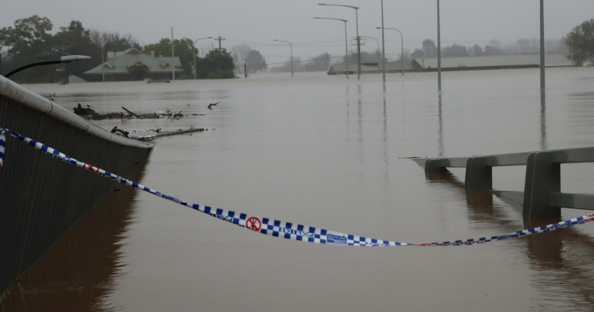
A River Flood Watch is an official alert from the National Weather Service, signaling that river flooding is possible but not yet certain. It's not a guarantee that flooding will occur, but rather a strong indication that specific conditions—such as intense or prolonged heavy rainfall, rapid snowmelt, or even controlled dam releases—could cause rivers to swell beyond their banks and exceed designated flood stages. The NWS issues these watches typically 6 to 48 hours in advance, providing a crucial window for preparation.
What makes a River Flood Watch distinct is its precision. Unlike broader flood watches that might cover entire counties, these alerts are geographically targeted, focusing on specific segments of rivers and their adjacent low-lying areas. Forecasters use detailed hydrological models, current river gauge data, and precipitation forecasts to assess the probability of a river reaching or exceeding flood stage at identified forecast points. If this assessment indicates a 50% to 80% likelihood, a River Flood Watch is issued. This targeted approach ensures that resources and attention are directed to where they are most needed, preventing unnecessary panic while alerting those truly at risk.
For residents, this means that even if your entire county isn't under a watch, specific areas along a river might be. It's a call for heightened awareness and initial preparedness, not immediate evacuation. This early notification system is paramount for allowing individuals and emergency managers to monitor conditions, secure property, and develop contingency plans without the urgency required by an active flood event.
The Science Behind the Alert: How Flood Watches are Issued
Issuing a Flood Watch is a complex process that goes beyond merely observing heavy rain. It involves a sophisticated interplay of science, technology, and human expertise. The National Weather Service relies on a network of sensors, satellite imagery, radar data, and advanced hydrological models to predict how much water will flow into river systems and how quickly it will accumulate. But the data is just one piece of the puzzle.
Decision-makers responsible for initiating flood warnings must weigh several critical factors:
- Forecast Reliability: How accurate are the precipitation and runoff forecasts, and how might that accuracy change with lead-time? There's a constant effort to refine models and integrate real-time data.
- Public Response Time: How much time would the public need to effectively respond to a warning, given varying geographical conditions and population densities?
- Warning Dissemination Delay: What is the lag between the warning being issued and its receipt by the public through various channels like NOAA Weather Radio, NWS websites, local media, and emergency alerts?
- Avoiding False Alarms: There's a delicate balance to strike. Issuing warnings unnecessarily can lead to "warning fatigue," where people become complacent and less likely to respond to future, genuine threats. This wastes public and emergency responder efforts.
- Consistency of Alerts: Rescinding a warning only to re-issue it shortly after can undermine public trust and cause significant inconvenience. Decisions are made with an eye toward stability and clarity.
Internally, the NWS and its partner organizations involved in emergency response utilize sophisticated computer systems. These systems include sub-systems for flood forecasting, automatic alerting of internal staff, tracking of alert messages, and even diverting messages to alternate personnel if acknowledgements aren't received. This robust infrastructure ensures that once a decision is made, the alert propagates swiftly and reliably to those who need to act. For a deeper dive into this intricate process, consider reading Understanding Flood Watch: How Decisions & Alerts Are Issued.
From Watch to Warning: A Graded Approach to Safety
The NWS employs a tiered alert system to provide graduated levels of preparedness, helping the public distinguish between potential threats and immediate dangers. This system is crucial for effective flood risk management and ensures that responses are proportionate to the threat level.
- River Flood Watch: This is the initial alert. As discussed, it means river flooding is possible within the next 6-48 hours, with a 50% to 80% probability. The recommended actions during a watch are centered around preparation and monitoring. Think of it as your cue to "be prepared" and "stay informed."
- River Flood Warning: This is a more urgent alert. A River Flood Warning is issued when forecasters have high confidence (typically above 80%) that river flooding is either imminent or already occurring. This signifies a direct threat to life and property, requiring immediate action. When a warning is issued, the guidance shifts from "prepare" to "act now" – this may include evacuation or seeking higher ground.
This clear distinction is vital because riverine flooding, characterized by slow-rising overflows from sustained water accumulation, behaves differently from rapid-onset flash flooding. While flash floods demand immediate, often split-second decisions, river flood watches and warnings offer a structured timeline for response. The progression from a watch to a warning allows individuals and communities to move from planning to execution seamlessly, mitigating risks more effectively. To understand the critical transition from possibility to certainty, explore NWS River Flood Watch: From Possibility to Imminent Warning.
Your Role During a River Flood Watch: Practical Preparedness Steps
A River Flood Watch isn't just a piece of information; it's a call to action for preparedness. Your proactive measures during this period can significantly reduce risks to life and property. Here are practical steps you should take:
- Stay Informed: This is paramount. Monitor official sources like NWS websites (weather.gov), NOAA Weather Radio, local news, and trusted social media channels. Pay attention to specific details regarding affected river segments and forecast points. Consider signing up for local emergency alerts through your city or county.
- Know Your Risk: Understand if your home or workplace is in a low-lying area or a flood-prone zone. FEMA flood maps can provide valuable insights into your property's flood risk.
- Prepare an Emergency Kit: Assemble a "go-bag" with essentials for at least 72 hours. This should include water, non-perishable food, a first-aid kit, medications, a flashlight, batteries, a hand-crank or battery-powered radio, important documents (copies in waterproof bags), and some cash.
- Secure Your Property: If time and safety permit, move valuable items, important documents, and electronics to higher floors or secure them in waterproof containers. Clear drains and gutters. Anchor outdoor items that could float away, such as trash cans or patio furniture.
- Develop an Emergency Plan: Discuss with your family what you will do if flooding occurs. Identify evacuation routes, designate a meeting point outside your immediate area, and establish communication methods. Practice your plan.
- Review Insurance Policies: Most standard homeowner's insurance policies do not cover flood damage. Review your policy and consider purchasing flood insurance if you live in a flood-prone area. There is typically a waiting period before flood insurance coverage takes effect, so act well in advance.
- Protect Documents: Keep copies of critical documents (birth certificates, deeds, insurance policies) in a waterproof, easily accessible bag or stored digitally in a cloud service.
- Charge Devices: Ensure your cell phone, laptops, and power banks are fully charged in case of power outages.
- Never Drive Through Floodwaters: Even during a watch, if you encounter standing water, remember the slogan: "Turn Around, Don't Drown." Just six inches of moving water can knock an adult off their feet, and 12 inches can sweep away most cars.
Conclusion
The River Flood Watch is a cornerstone of the National Weather Service's commitment to public safety. It’s a sophisticated, carefully considered alert designed to empower you with knowledge and time. By understanding its meaning, respecting the science behind its issuance, and taking proactive steps during a watch, you play a vital role in protecting yourself, your loved ones, and your community. Staying informed through official channels and having a well-rehearsed emergency plan are your best defenses against the potential hazards of river flooding. Don't wait for the warning; prepare during the watch.